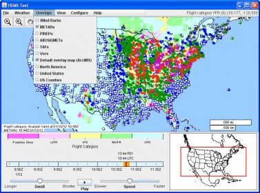
The Helicopter Emergency Medical Services (HEMS) Tool has been specially designed to meet the needs of low-altitude VFR emergency first responders. It runs as a desktop application on your computer for maximum performance.
The HEMS Tool can overlay multiple fields of interest: ceiling, visibility, flight category, winds, relative humidity, temperature, radar (base and composite reflectivity), AIRMETs and SIGMETs, METARs, TAFs, and PIREPs.
All 3D data are interpolated to AGL altitudes and can be sliced horizontally on 500 ft intervals up to 5000 ft. All data can be animated in time.
The tool has high-resolution basemaps, including streets, hospitals, and heliports for the entire United States. More detail is revealed as you zoom in.
Comments (1)